Showing:

Attributes
Diagrams
Instances
Properties
Source
Used by
Element womlswo:SurfacePrecipitationArea
Namespace http://xml.fmi.fi/namespace/woml/2010/05/28/swo
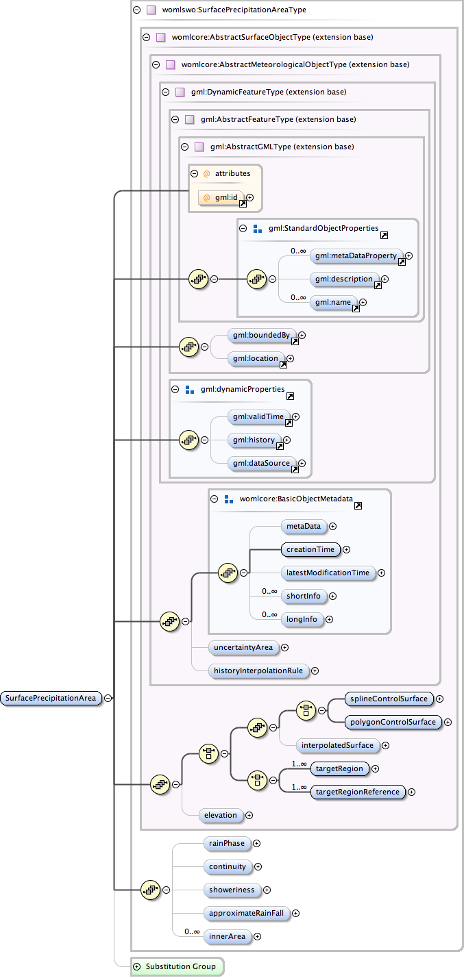
Diagram
Diagram docindex33.tmp#id56 docindex34.tmp#id38 docindex35.tmp#id51 docindex36.tmp#id53 docindex37.tmp#id37 docindex38.tmp#id36 docindex108.tmp#id57 docindex109.tmp#id87 docindex110.tmp#id35 docindex111.tmp#id118 docindex112.tmp#id129 docindex113.tmp#id138 docindex114.tmp#id117 docindex115.tmp#id34 docindex116.tmp#id140 docindex116.tmp#id165 docindex116.tmp#id166 docindex116.tmp#id167 docindex116.tmp#id169 docindex116.tmp#id139 docindex117.tmp#id172 docindex117.tmp#id198 docindex117.tmp#id33 docindex149.tmp#id884 docindex149.tmp#id890 docindex149.tmp#id895 docindex149.tmp#id901 docindex149.tmp#id902 docindex149.tmp#id903 docindex149.tmp#id883 docindex241.tmp#id1000 docindex241.tmp#id1002 docindex241.tmp#id1003 docindex241.tmp#id1004 docindex241.tmp#id1005 docindex241.tmp#id999
Type womlswo:SurfacePrecipitationAreaType
Type hierarchy
Properties
content: complex
Used by
Model gml:metaDataProperty* , gml:description{0,1} , gml:name* , gml:boundedBy{0,1} , gml:location{0,1} , gml:validTime{0,1} , gml:history{0,1} , gml:dataSource{0,1} , womlcore:metaData{0,1} , womlcore:creationTime , womlcore:latestModificationTime{0,1} , womlcore:shortInfo* , womlcore:longInfo* , womlcore:uncertaintyArea{0,1} , womlcore:historyInterpolationRule{0,1} , (((womlcore:splineControlSurface | womlcore:polygonControlSurface) , womlcore:interpolatedSurface{0,1}) | womlcore:targetRegion+ | womlcore:targetRegionReference+) , womlcore:elevation{0,1} , womlswo:rainPhase{0,1} , womlswo:continuity{0,1} , womlswo:showeriness{0,1} , womlswo:approximateRainFall{0,1} , womlswo:innerArea*
Children gml:boundedBy, gml:dataSource, gml:description, gml:history, gml:location, gml:metaDataProperty, gml:name, gml:validTime, womlcore:creationTime, womlcore:elevation, womlcore:historyInterpolationRule, womlcore:interpolatedSurface, womlcore:latestModificationTime, womlcore:longInfo, womlcore:metaData, womlcore:polygonControlSurface, womlcore:shortInfo, womlcore:splineControlSurface, womlcore:targetRegion, womlcore:targetRegionReference, womlcore:uncertaintyArea, womlswo:approximateRainFall, womlswo:continuity, womlswo:innerArea, womlswo:rainPhase, womlswo:showeriness
Instance
<womlswo:SurfacePrecipitationArea gml:id="">
  <gml:metaDataProperty about="" xlink:actuate="" xlink:arcrole="" xlink:href="" gml:remoteSchema="" xlink:role="" xlink:show="" xlink:title="" xlink:type="simple">{0,unbounded}</gml:metaDataProperty>
  <gml:description xlink:actuate="" xlink:arcrole="" xlink:href="" gml:remoteSchema="" xlink:role="" xlink:show="" xlink:title="" xlink:type="simple">{0,1}</gml:description>
  <gml:name codeSpace="">{0,unbounded}</gml:name>
</womlswo:SurfacePrecipitationArea>
Attributes
QName Type Fixed Default Use Annotation
gml:id ID optional
Database handle for the object. It is of XML type ID, so is constrained to be unique in the XML document within which it occurs. An external identifier for the object in the form of a URI may be constructed using standard XML and XPointer methods. This is done by concatenating the URI for the document, a fragment separator, and the value of the id attribute.
Source
<element name="SurfacePrecipitationArea" type="womlswo:SurfacePrecipitationAreaType" substitutionGroup="womlcore:AbstractSurfaceObject"/>
Schema location http://xml.fmi.fi/schema/woml/2010/05/28/swo/woml-precipitation.xsd