Showing:

Annotations
Attributes
Diagrams
Instances
Properties
Source
Used by
Element gml:EngineeringCRS
Namespace http://www.opengis.net/gml/3.2
Annotations
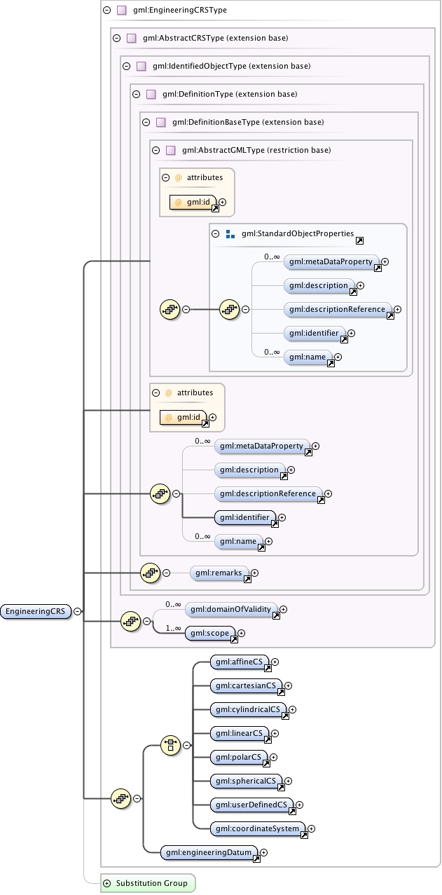
gml:EngineeringCRS is a contextually local coordinate reference system which can be divided into two broad categories:
-	earth-fixed systems applied to engineering activities on or near the surface of the earth;
-	CRSs on moving platforms such as road vehicles, vessels, aircraft, or spacecraft, see ISO 19111 8.3.
Diagram
Diagram index7.tmp#id74 index8.tmp#id68 index9.tmp#id89 index10.tmp#id91 index11.tmp#id95 index12.tmp#id100 index13.tmp#id67 index14.tmp#id66 index7.tmp#id74 index8.tmp#id68 index9.tmp#id89 index10.tmp#id91 index11.tmp#id95 index12.tmp#id100 index119.tmp#id766 index120.tmp#id767 index121.tmp#id765 index122.tmp#id1043 index136.tmp#id1044 index137.tmp#id1116 index196.tmp#id1042 index723.tmp#id1318 index659.tmp#id1261 index784.tmp#id1322 index785.tmp#id1325 index786.tmp#id1328 index787.tmp#id1265 index788.tmp#id1331 index789.tmp#id1313 index790.tmp#id1334 index1005.tmp#id1317
Type gml:EngineeringCRSType
Type hierarchy
Properties
content: complex
Used by
Model gml:metaDataProperty* , gml:description{0,1} , gml:descriptionReference{0,1} , gml:identifier , gml:name* , gml:remarks{0,1} , gml:domainOfValidity* , gml:scope+ , (gml:affineCS | gml:cartesianCS | gml:cylindricalCS | gml:linearCS | gml:polarCS | gml:sphericalCS | gml:userDefinedCS | gml:coordinateSystem) , gml:engineeringDatum
Children gml:affineCS, gml:cartesianCS, gml:coordinateSystem, gml:cylindricalCS, gml:description, gml:descriptionReference, gml:domainOfValidity, gml:engineeringDatum, gml:identifier, gml:linearCS, gml:metaDataProperty, gml:name, gml:polarCS, gml:remarks, gml:scope, gml:sphericalCS, gml:userDefinedCS
Instance
<gml:EngineeringCRS gml:id="">
  <gml:metaDataProperty about="" xlink:actuate="" xlink:arcrole="" xlink:href="" nilReason="" gml:remoteSchema="" xlink:role="" xlink:show="" xlink:title="" xlink:type="simple">{0,unbounded}</gml:metaDataProperty>
  <gml:description xlink:actuate="" xlink:arcrole="" xlink:href="" nilReason="" gml:remoteSchema="" xlink:role="" xlink:show="" xlink:title="" xlink:type="simple">{0,1}</gml:description>
  <gml:descriptionReference xlink:actuate="" xlink:arcrole="" xlink:href="" nilReason="" owns="false" gml:remoteSchema="" xlink:role="" xlink:show="" xlink:title="" xlink:type="simple">{0,1}</gml:descriptionReference>
  <gml:identifier codeSpace="">{1,1}</gml:identifier>
  <gml:name codeSpace="">{0,unbounded}</gml:name>
</gml:EngineeringCRS>
Attributes
QName Type Fixed Default Use Annotation
gml:id ID required
The attribute gml:id supports provision of a handle for the XML element representing a GML Object. Its use is mandatory for all GML objects. It is of XML type ID, so is constrained to be unique in the XML document within which it occurs.
Source
<element name="EngineeringCRS" type="gml:EngineeringCRSType" substitutionGroup="gml:AbstractSingleCRS">
  <annotation>
    <documentation>gml:EngineeringCRS is a contextually local coordinate reference system which can be divided into two broad categories: - earth-fixed systems applied to engineering activities on or near the surface of the earth; - CRSs on moving platforms such as road vehicles, vessels, aircraft, or spacecraft, see ISO 19111 8.3.</documentation>
  </annotation>
</element>
Schema location http://schemas.opengis.net/gml/3.2.1/coordinateReferenceSystems.xsd