Showing:

Annotations
Attributes
Diagrams
Instances
Properties
Source
Used by
Element gml:VerticalCRS
Namespace http://www.opengis.net/gml/3.2
Annotations
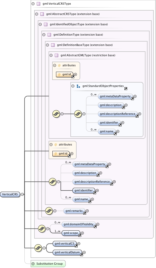
gml:VerticalCRS is a 1D coordinate reference system used for recording heights or depths. Vertical CRSs make use of the direction of gravity to define the concept of height or depth, but the relationship with gravity may not be straightforward. By implication, ellipsoidal heights (h) cannot be captured in a vertical coordinate reference system. Ellipsoidal heights cannot exist independently, but only as an inseparable part of a 3D coordinate tuple defined in a geographic 3D coordinate reference system.
Diagram
Diagram index0.tmp#id79 index1.tmp#id73 index2.tmp#id94 index3.tmp#id96 index4.tmp#id100 index5.tmp#id105 index6.tmp#id72 index7.tmp#id71 index0.tmp#id79 index1.tmp#id73 index2.tmp#id94 index3.tmp#id96 index4.tmp#id100 index5.tmp#id105 index113.tmp#id666 index114.tmp#id667 index115.tmp#id665 index116.tmp#id997 index117.tmp#id998 index118.tmp#id1070 index119.tmp#id996 index1259.tmp#id1249 index1260.tmp#id1253 index1261.tmp#id1248
Type gml:VerticalCRSType
Type hierarchy
Properties
content: complex
Used by
Model gml:metaDataProperty* , gml:description{0,1} , gml:descriptionReference{0,1} , gml:identifier , gml:name* , gml:remarks{0,1} , gml:domainOfValidity* , gml:scope+ , gml:verticalCS , gml:verticalDatum
Children gml:description, gml:descriptionReference, gml:domainOfValidity, gml:identifier, gml:metaDataProperty, gml:name, gml:remarks, gml:scope, gml:verticalCS, gml:verticalDatum
Instance
<gml:VerticalCRS gml:id="">
  <gml:metaDataProperty about="" xlink:actuate="" xlink:arcrole="" xlink:href="" nilReason="" gml:remoteSchema="" xlink:role="" xlink:show="" xlink:title="" xlink:type="simple">{0,unbounded}</gml:metaDataProperty>
  <gml:description xlink:actuate="" xlink:arcrole="" xlink:href="" nilReason="" gml:remoteSchema="" xlink:role="" xlink:show="" xlink:title="" xlink:type="simple">{0,1}</gml:description>
  <gml:descriptionReference xlink:actuate="" xlink:arcrole="" xlink:href="" nilReason="" owns="false" gml:remoteSchema="" xlink:role="" xlink:show="" xlink:title="" xlink:type="simple">{0,1}</gml:descriptionReference>
  <gml:identifier codeSpace="">{1,1}</gml:identifier>
  <gml:name codeSpace="">{0,unbounded}</gml:name>
</gml:VerticalCRS>
Attributes
QName Type Fixed Default Use Annotation
gml:id ID required
The attribute gml:id supports provision of a handle for the XML element representing a GML Object. Its use is mandatory for all GML objects. It is of XML type ID, so is constrained to be unique in the XML document within which it occurs.
Source
<element name="VerticalCRS" type="gml:VerticalCRSType" substitutionGroup="gml:AbstractSingleCRS">
  <annotation>
    <documentation>gml:VerticalCRS is a 1D coordinate reference system used for recording heights or depths. Vertical CRSs make use of the direction of gravity to define the concept of height or depth, but the relationship with gravity may not be straightforward. By implication, ellipsoidal heights (h) cannot be captured in a vertical coordinate reference system. Ellipsoidal heights cannot exist independently, but only as an inseparable part of a 3D coordinate tuple defined in a geographic 3D coordinate reference system.</documentation>
  </annotation>
</element>
Schema location http://schemas.opengis.net/gml/3.2.1/coordinateReferenceSystems.xsd