Showing:

Annotations
Attributes
Diagrams
Instances
Properties
Source
Used by
Element gml:UserDefinedCS
Namespace http://www.opengis.net/gml/3.2
Annotations
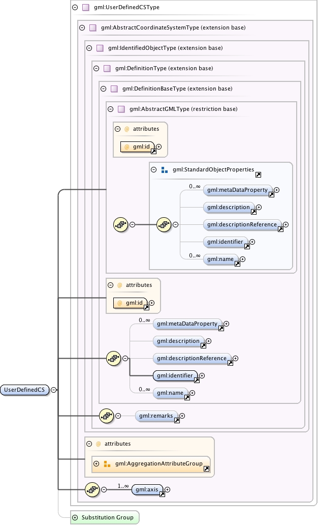
gml:UserDefinedCS is a two- or three-dimensional coordinate system that consists of any combination of coordinate axes not covered by any other coordinate system type. A UserDefinedCS shall have two or three gml:axis property elements; the number of property elements shall equal the dimension of the CS.
Diagram
Diagram index0.tmp#id76 index1.tmp#id70 index2.tmp#id91 index3.tmp#id93 index4.tmp#id97 index5.tmp#id102 index6.tmp#id69 index7.tmp#id68 index0.tmp#id76 index1.tmp#id70 index2.tmp#id91 index3.tmp#id93 index4.tmp#id97 index5.tmp#id102 index49.tmp#id635 index50.tmp#id636 index51.tmp#id634 index52.tmp#id962 index9.tmp#id422 index361.tmp#id1170 index362.tmp#id1169 index883.tmp#id1252
Type gml:UserDefinedCSType
Type hierarchy
Properties
content: complex
Used by
Model gml:metaDataProperty* , gml:description{0,1} , gml:descriptionReference{0,1} , gml:identifier , gml:name* , gml:remarks{0,1} , gml:axis+
Children gml:axis, gml:description, gml:descriptionReference, gml:identifier, gml:metaDataProperty, gml:name, gml:remarks
Instance
<gml:UserDefinedCS aggregationType="" gml:id="">
  <gml:metaDataProperty about="" xlink:actuate="" xlink:arcrole="" xlink:href="" nilReason="" gml:remoteSchema="" xlink:role="" xlink:show="" xlink:title="" xlink:type="simple">{0,unbounded}</gml:metaDataProperty>
  <gml:description xlink:actuate="" xlink:arcrole="" xlink:href="" nilReason="" gml:remoteSchema="" xlink:role="" xlink:show="" xlink:title="" xlink:type="simple">{0,1}</gml:description>
  <gml:descriptionReference xlink:actuate="" xlink:arcrole="" xlink:href="" nilReason="" owns="false" gml:remoteSchema="" xlink:role="" xlink:show="" xlink:title="" xlink:type="simple">{0,1}</gml:descriptionReference>
  <gml:identifier codeSpace="">{1,1}</gml:identifier>
  <gml:name codeSpace="">{0,unbounded}</gml:name>
</gml:UserDefinedCS>
Attributes
QName Type Fixed Default Use Annotation
aggregationType gml:AggregationType optional
gml:id ID required
The attribute gml:id supports provision of a handle for the XML element representing a GML Object. Its use is mandatory for all GML objects. It is of XML type ID, so is constrained to be unique in the XML document within which it occurs.
Source
<element name="UserDefinedCS" type="gml:UserDefinedCSType" substitutionGroup="gml:AbstractCoordinateSystem">
  <annotation>
    <documentation>gml:UserDefinedCS is a two- or three-dimensional coordinate system that consists of any combination of coordinate axes not covered by any other coordinate system type. A UserDefinedCS shall have two or three gml:axis property elements; the number of property elements shall equal the dimension of the CS.</documentation>
  </annotation>
</element>
Schema location http://schemas.opengis.net/gml/3.2.1/coordinateSystems.xsd