Showing:

Annotations
Attributes
Diagrams
Instances
Properties
Source
Used by
Element gml:EngineeringCRS
Namespace http://www.opengis.net/gml/3.2
Annotations
gml:EngineeringCRS is a contextually local coordinate reference system which can be divided into two broad categories:
-	earth-fixed systems applied to engineering activities on or near the surface of the earth;
-	CRSs on moving platforms such as road vehicles, vessels, aircraft, or spacecraft, see ISO 19111 8.3.
Diagram
Diagram index18.tmp#id85 index19.tmp#id79 index20.tmp#id100 index21.tmp#id102 index22.tmp#id106 index23.tmp#id111 index24.tmp#id78 index25.tmp#id77 index18.tmp#id85 index19.tmp#id79 index20.tmp#id100 index21.tmp#id102 index22.tmp#id106 index23.tmp#id111 index149.tmp#id581 index150.tmp#id582 index151.tmp#id580 index152.tmp#id930 index163.tmp#id931 index164.tmp#id1003 index359.tmp#id929 index940.tmp#id1205 index401.tmp#id1148 index1010.tmp#id1209 index1011.tmp#id1212 index1012.tmp#id1215 index402.tmp#id1152 index1013.tmp#id1218 index364.tmp#id1200 index1014.tmp#id1221 index1015.tmp#id1204
Type gml:EngineeringCRSType
Type hierarchy
Properties
content: complex
Used by
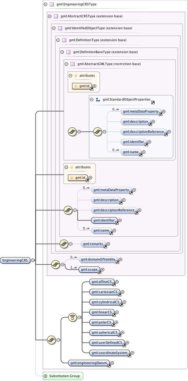
Model gml:metaDataProperty* , gml:description{0,1} , gml:descriptionReference{0,1} , gml:identifier , gml:name* , gml:remarks{0,1} , gml:domainOfValidity* , gml:scope+ , (gml:affineCS | gml:cartesianCS | gml:cylindricalCS | gml:linearCS | gml:polarCS | gml:sphericalCS | gml:userDefinedCS | gml:coordinateSystem) , gml:engineeringDatum
Children gml:affineCS, gml:cartesianCS, gml:coordinateSystem, gml:cylindricalCS, gml:description, gml:descriptionReference, gml:domainOfValidity, gml:engineeringDatum, gml:identifier, gml:linearCS, gml:metaDataProperty, gml:name, gml:polarCS, gml:remarks, gml:scope, gml:sphericalCS, gml:userDefinedCS
Instance
<gml:EngineeringCRS gml:id="">
  <gml:metaDataProperty about="" xlink:actuate="" xlink:arcrole="" xlink:href="" nilReason="" gml:remoteSchema="" xlink:role="" xlink:show="" xlink:title="" xlink:type="simple">{0,unbounded}</gml:metaDataProperty>
  <gml:description xlink:actuate="" xlink:arcrole="" xlink:href="" nilReason="" gml:remoteSchema="" xlink:role="" xlink:show="" xlink:title="" xlink:type="simple">{0,1}</gml:description>
  <gml:descriptionReference xlink:actuate="" xlink:arcrole="" xlink:href="" nilReason="" owns="false" gml:remoteSchema="" xlink:role="" xlink:show="" xlink:title="" xlink:type="simple">{0,1}</gml:descriptionReference>
  <gml:identifier codeSpace="">{1,1}</gml:identifier>
  <gml:name codeSpace="">{0,unbounded}</gml:name>
</gml:EngineeringCRS>
Attributes
QName Type Fixed Default Use Annotation
gml:id ID required
The attribute gml:id supports provision of a handle for the XML element representing a GML Object. Its use is mandatory for all GML objects. It is of XML type ID, so is constrained to be unique in the XML document within which it occurs.
Source
<element name="EngineeringCRS" type="gml:EngineeringCRSType" substitutionGroup="gml:AbstractSingleCRS">
  <annotation>
    <documentation>gml:EngineeringCRS is a contextually local coordinate reference system which can be divided into two broad categories: - earth-fixed systems applied to engineering activities on or near the surface of the earth; - CRSs on moving platforms such as road vehicles, vessels, aircraft, or spacecraft, see ISO 19111 8.3.</documentation>
  </annotation>
</element>
Schema location http://schemas.opengis.net/gml/3.2.1/coordinateReferenceSystems.xsd