Showing:

Annotations
Attributes
Diagrams
Instances
Properties
Source
Used by
Element gml:CartesianCS
Namespace http://www.opengis.net/gml/3.2
Annotations
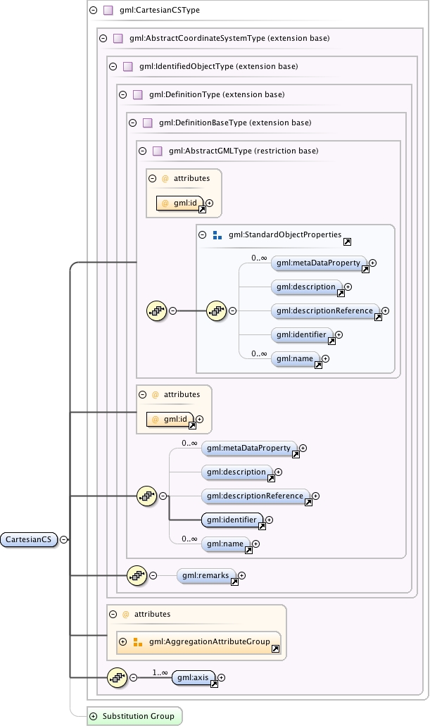
gml:CartesianCS is a 1-, 2-, or 3-dimensional coordinate system. In the 1-dimensional case, it contains a single straight coordinate axis. In the 2- and 3-dimensional cases gives the position of points relative to orthogonal straight axes. In the multi-dimensional case, all axes shall have the same length unit of measure. A CartesianCS shall have one, two, or three gml:axis property elements.
Diagram
Diagram index4.tmp#id85 index5.tmp#id79 index6.tmp#id100 index7.tmp#id102 index8.tmp#id106 index9.tmp#id111 index10.tmp#id78 index11.tmp#id77 index4.tmp#id85 index5.tmp#id79 index6.tmp#id100 index7.tmp#id102 index8.tmp#id106 index9.tmp#id111 index26.tmp#id592 index27.tmp#id593 index28.tmp#id591 index29.tmp#id941 index30.tmp#id373 index31.tmp#id1149 index32.tmp#id1148 index121.tmp#id1162
Type gml:CartesianCSType
Type hierarchy
Properties
content: complex
Used by
Model gml:metaDataProperty* , gml:description{0,1} , gml:descriptionReference{0,1} , gml:identifier , gml:name* , gml:remarks{0,1} , gml:axis+
Children gml:axis, gml:description, gml:descriptionReference, gml:identifier, gml:metaDataProperty, gml:name, gml:remarks
Instance
<gml:CartesianCS aggregationType="" gml:id="">
  <gml:metaDataProperty about="" xlink:actuate="" xlink:arcrole="" xlink:href="" nilReason="" gml:remoteSchema="" xlink:role="" xlink:show="" xlink:title="" xlink:type="simple">{0,unbounded}</gml:metaDataProperty>
  <gml:description xlink:actuate="" xlink:arcrole="" xlink:href="" nilReason="" gml:remoteSchema="" xlink:role="" xlink:show="" xlink:title="" xlink:type="simple">{0,1}</gml:description>
  <gml:descriptionReference xlink:actuate="" xlink:arcrole="" xlink:href="" nilReason="" owns="false" gml:remoteSchema="" xlink:role="" xlink:show="" xlink:title="" xlink:type="simple">{0,1}</gml:descriptionReference>
  <gml:identifier codeSpace="">{1,1}</gml:identifier>
  <gml:name codeSpace="">{0,unbounded}</gml:name>
</gml:CartesianCS>
Attributes
QName Type Fixed Default Use Annotation
aggregationType gml:AggregationType optional
gml:id ID required
The attribute gml:id supports provision of a handle for the XML element representing a GML Object. Its use is mandatory for all GML objects. It is of XML type ID, so is constrained to be unique in the XML document within which it occurs.
Source
<element name="CartesianCS" type="gml:CartesianCSType" substitutionGroup="gml:AbstractCoordinateSystem">
  <annotation>
    <documentation>gml:CartesianCS is a 1-, 2-, or 3-dimensional coordinate system. In the 1-dimensional case, it contains a single straight coordinate axis. In the 2- and 3-dimensional cases gives the position of points relative to orthogonal straight axes. In the multi-dimensional case, all axes shall have the same length unit of measure. A CartesianCS shall have one, two, or three gml:axis property elements.</documentation>
  </annotation>
</element>
Schema location http://schemas.opengis.net/gml/3.2.1/coordinateSystems.xsd