Showing:

Annotations
Attributes
Diagrams
Instances
Properties
Source
Used by
Element gml:EngineeringCRS
Namespace http://www.opengis.net/gml/3.2
Annotations
gml:EngineeringCRS is a contextually local coordinate reference system which can be divided into two broad categories:
-	earth-fixed systems applied to engineering activities on or near the surface of the earth;
-	CRSs on moving platforms such as road vehicles, vessels, aircraft, or spacecraft, see ISO 19111 8.3.
Diagram
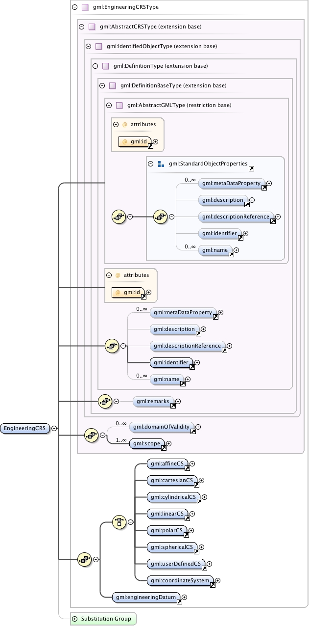
Diagram index0.tmp#id77 index1.tmp#id71 index2.tmp#id92 index3.tmp#id94 index4.tmp#id98 index5.tmp#id103 index6.tmp#id70 index7.tmp#id69 index0.tmp#id77 index1.tmp#id71 index2.tmp#id92 index3.tmp#id94 index4.tmp#id98 index5.tmp#id103 index8.tmp#id628 index9.tmp#id629 index10.tmp#id627 index11.tmp#id966 index12.tmp#id967 index13.tmp#id1039 index85.tmp#id965 index389.tmp#id1241 index87.tmp#id1184 index869.tmp#id1245 index870.tmp#id1248 index871.tmp#id1251 index88.tmp#id1188 index872.tmp#id1254 index873.tmp#id1236 index874.tmp#id1257 index875.tmp#id1240
Type gml:EngineeringCRSType
Type hierarchy
Properties
content: complex
Used by
Model gml:metaDataProperty* , gml:description{0,1} , gml:descriptionReference{0,1} , gml:identifier , gml:name* , gml:remarks{0,1} , gml:domainOfValidity* , gml:scope+ , (gml:affineCS | gml:cartesianCS | gml:cylindricalCS | gml:linearCS | gml:polarCS | gml:sphericalCS | gml:userDefinedCS | gml:coordinateSystem) , gml:engineeringDatum
Children gml:affineCS, gml:cartesianCS, gml:coordinateSystem, gml:cylindricalCS, gml:description, gml:descriptionReference, gml:domainOfValidity, gml:engineeringDatum, gml:identifier, gml:linearCS, gml:metaDataProperty, gml:name, gml:polarCS, gml:remarks, gml:scope, gml:sphericalCS, gml:userDefinedCS
Instance
<gml:EngineeringCRS gml:id="">
  <gml:metaDataProperty about="" xlink:actuate="" xlink:arcrole="" xlink:href="" nilReason="" gml:remoteSchema="" xlink:role="" xlink:show="" xlink:title="" xlink:type="simple">{0,unbounded}</gml:metaDataProperty>
  <gml:description xlink:actuate="" xlink:arcrole="" xlink:href="" nilReason="" gml:remoteSchema="" xlink:role="" xlink:show="" xlink:title="" xlink:type="simple">{0,1}</gml:description>
  <gml:descriptionReference xlink:actuate="" xlink:arcrole="" xlink:href="" nilReason="" owns="false" gml:remoteSchema="" xlink:role="" xlink:show="" xlink:title="" xlink:type="simple">{0,1}</gml:descriptionReference>
  <gml:identifier codeSpace="">{1,1}</gml:identifier>
  <gml:name codeSpace="">{0,unbounded}</gml:name>
</gml:EngineeringCRS>
Attributes
QName Type Fixed Default Use Annotation
gml:id ID required
The attribute gml:id supports provision of a handle for the XML element representing a GML Object. Its use is mandatory for all GML objects. It is of XML type ID, so is constrained to be unique in the XML document within which it occurs.
Source
<element name="EngineeringCRS" type="gml:EngineeringCRSType" substitutionGroup="gml:AbstractSingleCRS">
  <annotation>
    <documentation>gml:EngineeringCRS is a contextually local coordinate reference system which can be divided into two broad categories: - earth-fixed systems applied to engineering activities on or near the surface of the earth; - CRSs on moving platforms such as road vehicles, vessels, aircraft, or spacecraft, see ISO 19111 8.3.</documentation>
  </annotation>
</element>
Schema location http://schemas.opengis.net/gml/3.2.1/coordinateReferenceSystems.xsd