Showing:

Annotations
Attributes
Diagrams
Instances
Properties
Source
Used by
Element gml:AbstractCoordinateSystem
Namespace http://www.opengis.net/gml/3.2
Annotations
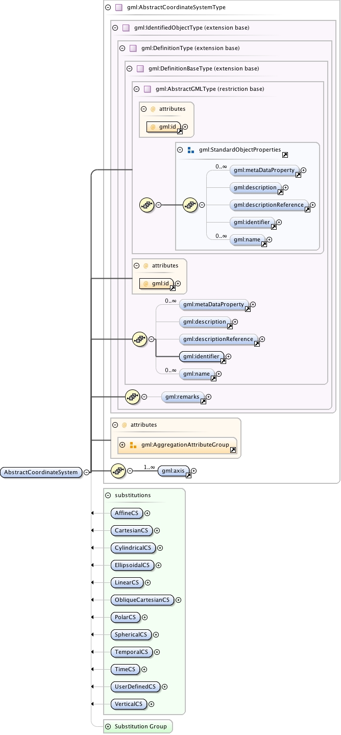
gml:AbstractCoordinateSystem is a coordinate system (CS) is the non-repeating sequence of coordinate system axes that spans a given coordinate space. A CS is derived from a set of mathematical rules for specifying how coordinates in a given space are to be assigned to points. The coordinate values in a coordinate tuple shall be recorded in the order in which the coordinate system axes associations are recorded. This abstract complex type shall not be used, extended, or restricted, in an Application Schema, to define a concrete subtype with a meaning equivalent to a concrete subtype specified in this document.
Diagram
Diagram index33.tmp#id78 index34.tmp#id72 index35.tmp#id100 index36.tmp#id102 index37.tmp#id106 index38.tmp#id111 index39.tmp#id71 index40.tmp#id70 index33.tmp#id78 index34.tmp#id72 index35.tmp#id100 index36.tmp#id102 index37.tmp#id106 index38.tmp#id111 index117.tmp#id587 index118.tmp#id588 index119.tmp#id586 index120.tmp#id941 index50.tmp#id371 index121.tmp#id1149 index122.tmp#id1148 index618.tmp#id637 index60.tmp#id629 index424.tmp#id636 index619.tmp#id628 index620.tmp#id632 index365.tmp#id639 index257.tmp#id635 index522.tmp#id634 index621.tmp#id638 index567.tmp#id631 index199.tmp#id633 index622.tmp#id630
Type gml:AbstractCoordinateSystemType
Type hierarchy
Properties
content: complex
abstract: true
Used by
Model gml:metaDataProperty* , gml:description{0,1} , gml:descriptionReference{0,1} , gml:identifier , gml:name* , gml:remarks{0,1} , gml:axis+
Children gml:axis, gml:description, gml:descriptionReference, gml:identifier, gml:metaDataProperty, gml:name, gml:remarks
Instance
<gml:AbstractCoordinateSystem aggregationType="" gml:id="">
  <gml:metaDataProperty about="" xlink:actuate="" xlink:arcrole="" xlink:href="" nilReason="" gml:remoteSchema="" xlink:role="" xlink:show="" xlink:title="" xlink:type="simple">{0,unbounded}</gml:metaDataProperty>
  <gml:description xlink:actuate="" xlink:arcrole="" xlink:href="" nilReason="" gml:remoteSchema="" xlink:role="" xlink:show="" xlink:title="" xlink:type="simple">{0,1}</gml:description>
  <gml:descriptionReference xlink:actuate="" xlink:arcrole="" xlink:href="" nilReason="" owns="false" gml:remoteSchema="" xlink:role="" xlink:show="" xlink:title="" xlink:type="simple">{0,1}</gml:descriptionReference>
  <gml:identifier codeSpace="">{1,1}</gml:identifier>
  <gml:name codeSpace="">{0,unbounded}</gml:name>
</gml:AbstractCoordinateSystem>
Attributes
QName Type Fixed Default Use Annotation
aggregationType gml:AggregationType optional
gml:id ID required
The attribute gml:id supports provision of a handle for the XML element representing a GML Object. Its use is mandatory for all GML objects. It is of XML type ID, so is constrained to be unique in the XML document within which it occurs.
Source
<element name="AbstractCoordinateSystem" type="gml:AbstractCoordinateSystemType" abstract="true" substitutionGroup="gml:Definition">
  <annotation>
    <documentation>gml:AbstractCoordinateSystem is a coordinate system (CS) is the non-repeating sequence of coordinate system axes that spans a given coordinate space. A CS is derived from a set of mathematical rules for specifying how coordinates in a given space are to be assigned to points. The coordinate values in a coordinate tuple shall be recorded in the order in which the coordinate system axes associations are recorded. This abstract complex type shall not be used, extended, or restricted, in an Application Schema, to define a concrete subtype with a meaning equivalent to a concrete subtype specified in this document.</documentation>
  </annotation>
</element>
Schema location http://schemas.opengis.net/gml/3.2.1/coordinateSystems.xsd