Showing:

Annotations
Attributes
Diagrams
Properties
Source
Used by
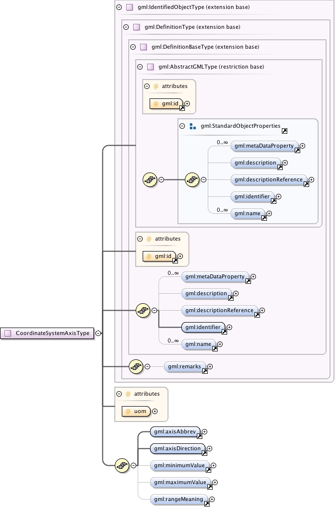
Complex Type gml:CoordinateSystemAxisType
Namespace http://www.opengis.net/gml/3.2
Diagram
Diagram index7.tmp#id74 index8.tmp#id68 index9.tmp#id89 index10.tmp#id91 index11.tmp#id95 index12.tmp#id100 index13.tmp#id67 index14.tmp#id66 index7.tmp#id74 index8.tmp#id68 index9.tmp#id89 index10.tmp#id91 index11.tmp#id95 index12.tmp#id100 index119.tmp#id766 index120.tmp#id767 index121.tmp#id765 index122.tmp#id1043 index427.tmp#id1260 index428.tmp#id1255 index429.tmp#id1256 index430.tmp#id1257 index431.tmp#id1258 index432.tmp#id1259
Type extension of gml:IdentifiedObjectType
Type hierarchy
Used by
Model gml:metaDataProperty* , gml:description{0,1} , gml:descriptionReference{0,1} , gml:identifier , gml:name* , gml:remarks{0,1} , gml:axisAbbrev , gml:axisDirection , gml:minimumValue{0,1} , gml:maximumValue{0,1} , gml:rangeMeaning{0,1}
Children gml:axisAbbrev, gml:axisDirection, gml:description, gml:descriptionReference, gml:identifier, gml:maximumValue, gml:metaDataProperty, gml:minimumValue, gml:name, gml:rangeMeaning, gml:remarks
Attributes
QName Type Fixed Default Use Annotation
gml:id ID required
The attribute gml:id supports provision of a handle for the XML element representing a GML Object. Its use is mandatory for all GML objects. It is of XML type ID, so is constrained to be unique in the XML document within which it occurs.
uom gml:UomIdentifier required
The uom attribute provides an identifier of the unit of measure used for this coordinate system axis. The value of this coordinate in a coordinate tuple shall be recorded using this unit of measure, whenever those coordinates use a coordinate reference system that uses a coordinate system that uses this axis.
Source
<complexType name="CoordinateSystemAxisType">
  <complexContent>
    <extension base="gml:IdentifiedObjectType">
      <sequence>
        <element ref="gml:axisAbbrev"/>
        <element ref="gml:axisDirection"/>
        <element ref="gml:minimumValue" minOccurs="0"/>
        <element ref="gml:maximumValue" minOccurs="0"/>
        <element ref="gml:rangeMeaning" minOccurs="0"/>
      </sequence>
      <attribute name="uom" type="gml:UomIdentifier" use="required">
        <annotation>
          <documentation>The uom attribute provides an identifier of the unit of measure used for this coordinate system axis. The value of this coordinate in a coordinate tuple shall be recorded using this unit of measure, whenever those coordinates use a coordinate reference system that uses a coordinate system that uses this axis.</documentation>
        </annotation>
      </attribute>
    </extension>
  </complexContent>
</complexType>
Schema location http://schemas.opengis.net/gml/3.2.1/coordinateSystems.xsd
Attribute gml:CoordinateSystemAxisType / @uom
Namespace No namespace
Annotations
The uom attribute provides an identifier of the unit of measure used for this coordinate system axis. The value of this coordinate in a coordinate tuple shall be recorded using this unit of measure, whenever those coordinates use a coordinate reference system that uses a coordinate system that uses this axis.
Type gml:UomIdentifier
Properties
use: required
Used by
Source
<attribute name="uom" type="gml:UomIdentifier" use="required">
  <annotation>
    <documentation>The uom attribute provides an identifier of the unit of measure used for this coordinate system axis. The value of this coordinate in a coordinate tuple shall be recorded using this unit of measure, whenever those coordinates use a coordinate reference system that uses a coordinate system that uses this axis.</documentation>
  </annotation>
</attribute>
Schema location http://schemas.opengis.net/gml/3.2.1/coordinateSystems.xsd