The 'actuate' attribute is used to communicate the desired timing of traversal from the starting resource to the ending resource; it's value should be treated as follows:onLoad - traverse to the ending resource immediately on loading the starting resource onRequest - traverse from the starting resource to the ending resource only on a post-loading event triggered for this purpose other - behavior is unconstrained; examine other markup in link for hints none - behavior is unconstrained
The 'show' attribute is used to communicate the desired presentation of the ending resource on traversal from the starting resource; it's value should be treated as follows: new - load ending resource in a new window, frame, pane, or other presentation contextreplace - load the resource in the same window, frame, pane, or other presentation contextembed - load ending resource in place of the presentation of the starting resourceother - behavior is unconstrained; examine other markup in the link for hints none - behavior is unconstrained
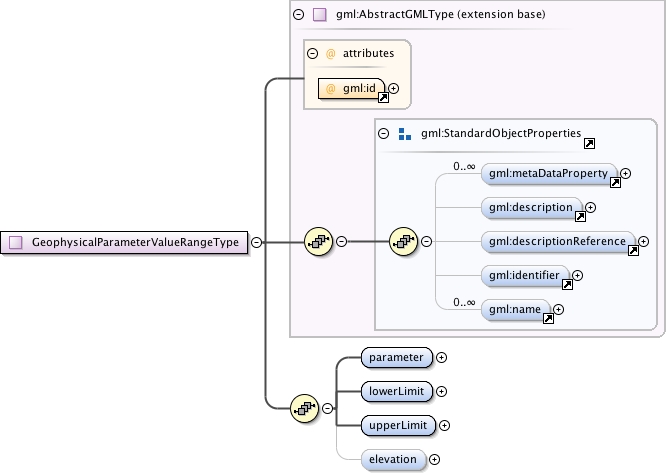
<html:div xmlns="http://www.w3.org/1999/xhtml"><p>Value range of a geophysical parameter (temperature, pressure, humidity,..) at some point-like location and at a specific time. The truth value of this statement is not considered here, value may be speculative (forecast). The main intention for objects of this type is to represent forecast parameter value ranges on a map.</p><p>Preferred font size in points for the label can specified with the preferredRenderingSize property by using "pt" as the uom (Unit Of Measure) attribute of "value".</p></html:div>
The attribute gml:id supports provision of a handle for the XML element representing a GML Object. Its use is mandatory for all GML objects. It is of XML type ID, so is constrained to be unique in the XML document within which it occurs.
Source
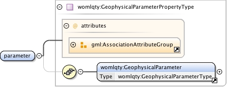
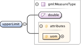
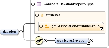
<complexType name="GeophysicalParameterValueRangeType"><annotation><documentation><html:div xmlns="http://www.w3.org/1999/xhtml"><p>Value range of a geophysical parameter (temperature, pressure, humidity,..) at some point-like location and at a specific time. The truth value of this statement is not considered here, value may be speculative (forecast). The main intention for objects of this type is to represent forecast parameter value ranges on a map.</p><p>Preferred font size in points for the label can specified with the preferredRenderingSize property by using "pt" as the uom (Unit Of Measure) attribute of "value".</p></html:div></documentation></annotation><complexContent><extension base="gml:AbstractGMLType"><sequence><element name="parameter" type="womlqty:GeophysicalParameterPropertyType" minOccurs="1" maxOccurs="1"/><element name="lowerLimit" type="gml:MeasureType" minOccurs="1" maxOccurs="1"/><element name="upperLimit" type="gml:MeasureType" minOccurs="1" maxOccurs="1"/><element name="elevation" type="womlcore:ElevationPropertyType" minOccurs="0" maxOccurs="1"/></sequence></extension></complexContent></complexType>