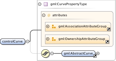
This element specifies the definitive geometry of the center line of the given line object in the given CRS.Applications should use this information in rendering the line object when ever possible.The using applications should note, that rendering the line in other CRS (projection) that the given oneprobably requires a more complex path matching than simply re-projecting the control points. One possible waywould be sampling the curve as lineString with appropriate frequency, translating the sampled lineString,and finally fitting a new cubic spline to the sampled and translated lineString.
<element name="controlCurve" type="gml:CurvePropertyType" minOccurs="1" maxOccurs="1"><annotation><documentation>This element specifies the definitive geometry of the center line of the given line object in the given CRS. Applications should use this information in rendering the line object when ever possible. The using applications should note, that rendering the line in other CRS (projection) that the given one probably requires a more complex path matching than simply re-projecting the control points. One possible way would be sampling the curve as lineString with appropriate frequency, translating the sampled lineString, and finally fitting a new cubic spline to the sampled and translated lineString.</documentation></annotation></element>
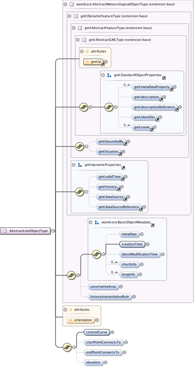
Abstract parent type for WOML Objects defined line segments
                        between an ordered set of geospatial points.

                    The points defined in each of the given line segments
                        should be considered as one consecutive array of geospatial points. If there are more
                        that one segment, the first point (in the orientation order) of each of the segments
                        following the first one is ignored (the first and the last point coordinates
                        must always represent the same point).

                    The orientation of the line is defined by attribute "orientation", starting from the first position
                        in the position list and ending to the last position if positive.
                        This may or may not affect the semantics and the rendering of the line object
                        (depending on whether the concrete types have a natural direction or not).

                    If elevation
                        property is given, its value must be added to possible height value of each of the
                        points in the each line segment. If the CRS of the points is 2-dimensional, the
                        value of the elevation should be interpreted as the static height value of each of
                        the given (control)points.
The attribute gml:id supports provision of a handle for the XML element representing a GML Object. Its use is mandatory for all GML objects. It is of XML type ID, so is constrained to be unique in the XML document within which it occurs.
<complexType name="AbstractLineObjectType" abstract="true"><annotation><documentation>Abstract parent type for WOML Objects defined line segments between an ordered set of geospatial points. The points defined in each of the given line segments should be considered as one consecutive array of geospatial points. If there are more that one segment, the first point (in the orientation order) of each of the segments following the first one is ignored (the first and the last point coordinates must always represent the same point). The orientation of the line is defined by attribute "orientation", starting from the first position in the position list and ending to the last position if positive. This may or may not affect the semantics and the rendering of the line object (depending on whether the concrete types have a natural direction or not). If elevation property is given, its value must be added to possible height value of each of the points in the each line segment. If the CRS of the points is 2-dimensional, the value of the elevation should be interpreted as the static height value of each of the given (control)points.</documentation></annotation><complexContent><extension base="womlcore:AbstractMeteorologicalObjectType"><sequence><element name="controlCurve" type="gml:CurvePropertyType" minOccurs="1" maxOccurs="1"><annotation><documentation>This element specifies the definitive geometry of the center line of the given line object in the given CRS. Applications should use this information in rendering the line object when ever possible. The using applications should note, that rendering the line in other CRS (projection) that the given one probably requires a more complex path matching than simply re-projecting the control points. One possible way would be sampling the curve as lineString with appropriate frequency, translating the sampled lineString, and finally fitting a new cubic spline to the sampled and translated lineString.</documentation></annotation></element><element name="startPointConnectsTo" type="womlcore:ConnectionPointReferenceType" minOccurs="0" maxOccurs="1"/><element name="endPointConnectsTo" type="womlcore:ConnectionPointReferenceType" minOccurs="0" maxOccurs="1"/><element name="elevation" type="womlcore:ElevationPropertyType" minOccurs="0" maxOccurs="1"/></sequence><attribute name="orientation" type="gml:SignType" default="+" use="optional"/></extension></complexContent></complexType>