Reference to an XML Schema fragment that specifies the content model of the propertys value. This is in conformance with the XML Schema Section 4.14 Referencing Schemas from Elsewhere.
The 'actuate' attribute is used to communicate the desired timing of traversal from the starting resource to the ending resource; it's value should be treated as follows:onLoad - traverse to the ending resource immediately on loading the starting resource onRequest - traverse from the starting resource to the ending resource only on a post-loading event triggered for this purpose other - behavior is unconstrained; examine other markup in link for hints none - behavior is unconstrained
The 'show' attribute is used to communicate the desired presentation of the ending resource on traversal from the starting resource; it's value should be treated as follows: new - load ending resource in a new window, frame, pane, or other presentation contextreplace - load the resource in the same window, frame, pane, or other presentation contextembed - load ending resource in place of the presentation of the starting resourceother - behavior is unconstrained; examine other markup in the link for hints none - behavior is unconstrained
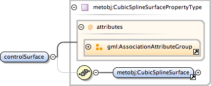
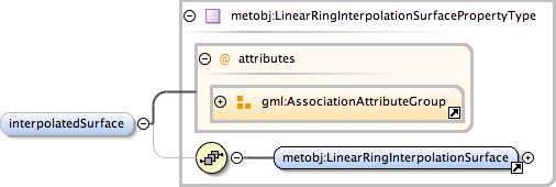
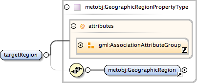
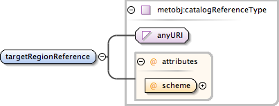
<html:div xmlns="http://www.w3.org/1999/xhtml"><p>Surface object's area may be defined either as a single "anonymous", continuous surface patch or using named geographic regions (e.g. administrative areas).</p><p>When using the "anonymous" definition, the surface can be an abstraction of a portion of ground (like rain or cloud area) or an elevated surface at some level above ground.</p><p>The target area is defined by element "surface" containing one exterior ring (closed route through n coordinate points) and zero or more interior rings defining excluded areas ("holes") inside the exterior. type of the interpolation between the surface points can be specified by using attribute "interpolation".</p><p>If elevation property is given, its value must be added to possible height value of each of the points in the each line segment. If the CRS of the points is 2-dimensional, the value of the elevation should be interpreted as the static height value of each of the given (control)points.</p><p>An alternative for "anonymous" surface patch definitions is to use a set of know and named, usually administrative areas. These regions may be give inline or by references to the set included in the "sharedGeographicRegions" list of the containing Met Object group.</p></html:div>
Database handle for the object. It is of XML type ID, so is constrained to be unique in the XML document within which it occurs. An external identifier for the object in the form of a URI may be constructed using standard XML and XPointer methods. This is done by concatenating the URI for the document, a fragment separator, and the value of the id attribute.
Source
<complexType name="AbstractSurfaceObjectType"><annotation><documentation><html:div xmlns="http://www.w3.org/1999/xhtml"><p>Surface object's area may be defined either as a single "anonymous", continuous surface patch or using named geographic regions (e.g. administrative areas).</p><p>When using the "anonymous" definition, the surface can be an abstraction of a portion of ground (like rain or cloud area) or an elevated surface at some level above ground.</p><p>The target area is defined by element "surface" containing one exterior ring (closed route through n coordinate points) and zero or more interior rings defining excluded areas ("holes") inside the exterior. type of the interpolation between the surface points can be specified by using attribute "interpolation".</p><p>If elevation property is given, its value must be added to possible height value of each of the points in the each line segment. If the CRS of the points is 2-dimensional, the value of the elevation should be interpreted as the static height value of each of the given (control)points.</p><p>An alternative for "anonymous" surface patch definitions is to use a set of know and named, usually administrative areas. These regions may be give inline or by references to the set included in the "sharedGeographicRegions" list of the containing Met Object group.</p></html:div></documentation></annotation><complexContent><extension base="metobj:AbstractMeteorologicalObjectType"><sequence><choice><sequence><element name="controlSurface" type="metobj:CubicSplineSurfacePropertyType" minOccurs="1" maxOccurs="1"/><element name="interpolatedSurface" type="metobj:LinearRingInterpolationSurfacePropertyType" minOccurs="0" maxOccurs="1"/></sequence><choice><element name="targetRegion" type="metobj:GeographicRegionPropertyType" minOccurs="1" maxOccurs="unbounded"/><element name="targetRegionReference" type="metobj:catalogReferenceType" minOccurs="1" maxOccurs="unbounded"/></choice></choice><element name="elevation" type="metobj:ElevationPropertyType" minOccurs="0" maxOccurs="1"/></sequence></extension></complexContent></complexType>